Denali II
The previous entry is Denali part one.
June 10
One of the stories Judith told us on the long bus ride down from Prudhoe Bay was about the time she flew on one of the flightseeing tours with a friend of hers to see Mt. McKinley (also called Denali, its Native American name; I’ll use the two names interchangably). It was a clear day, so the mountain was visible from far away. “How close are we getting?” “Pretty close.” As the plane flew down the valley near the mountain, Judith said Denali loomed ever larger over the plane, and she involuntarily leaned further and further away from the window. The pilot asked, “Close enough for you?” Yep. They were still about three miles from the slope. On the train ride from Fairbanks to Denali, a Holland America sales person came around selling the various excursions available from the McKinley Village hotel. After hearing the story, we signed up for only one, the flightseeing tour to the mountain.
A shuttle picked us up early in the morning and took us to the local airport. There, we were given a short lecture over a 3-dimensional model of area of the park we were going to fly over, telling us where we’d go, what we’d probably see (weather permitting: at any given time there are several distinct weather systems over Denali), what these formations are. Mt. McKinley dominated this topological model as it dominates the real landscape. We heard a little bit of history: the first climbers of Denali came from the north, taking a great deal of time to cross a group of rivers before being able to set up a basecamp to begin their ascent. The side they attempted has one of the great sheer walls in the world, a mile or two high. McKinley has two peaks, in fact, and these climbers summited on the shorter, closer one: they didn’t see the farther one because of the clouds until they got to the top.
The guide pointed to a larger glacial formation to the southwest of the mountain and noted that modern climbers set up basecamp on the glacier and ascend Denali from there. The climb now takes a couple of weeks instead of a couple of months, in large part because they don’t have to schlepp all their gear across a wide flood plain. (The guide didn’t know why the original climbers didn’t come from this direction. I suspect this route becomes feasible after the introduction of helicopters or other aircraft that can make a glacier landing. Also, all the logistics, i.e., roads and railheads, may be to the north of the mountain.) We might see climbers trudging along the glacier, weather permitting.
The guide left, and we were introduced to the pilots. Half the group — there were people from a different tour; from Tour 21, there was only one other couple for that time slot — went off and our pilot gave a quick “here’s where we’re going” talk over the map. Then we headed outside behind the building to the runway. Our plane was a two-engine, seven-seater for the six of us (including the pilot; there was an older woman there, too). If you believes commercial jets have narrow aisles and small seats, then you haven’t been aboard this sort of plane: it was cramped, but we all had window seats.
I should be a better editor and trim down the photos — we took a lot –but there was a certain awe and wonder as we soared around Denali, snow-capped peaks to our side or below us. We went a bit nuts with the cameras, snapping almost continuously for the 90-minute flight, trying to capture what we were seeing. At times, a shaft of sunlight would fill the cabin and the glare reflected from our jackets would fill the windows, detracting from the shots. (Perhaps someone with strong PhotoShop/GIMP kung fu will remove this glare in the future.) I should be a better editor and restrict the shots to the most interesting ones, but I find them all interesting: it’s a little of what we experienced when we were in the sky.
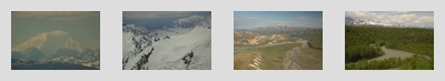
The first part of the flight was above the plains and valleys that we drove through on the bus the day before, the characteristic braided river of glacier melt below us. In fact, Grace (who had a telephoto lens on her camera; I had the 18-70mm kit lens because the telephoto would have been too cumbersome and not wide enough for these types of landscape) got a shot of one of those tour buses on the gravel road that snakes along the valley slopes. At some point, we flew well past Mile 55 and hitched left to circle the mountain clockwise, passing over the thickly glaciered valleys to the south.
Mountain walls, laced with snow and ice, rose high above us, growing indistinct in their swirling snow. These mountains have their own weather systems, and they’re almost invariably cloud covered with high winds. The glacial ice stretched far away into the snow storm, with glimpses of that almost artificial blue from small lakes below us. We passed over the base camp set up for the climbers, and saw a line of them making their way across the snow. We passed over the tracks of Dall Sheep impressed into the snowcap. There would be breaks in the clouds, and shafts of sunlight would touch parts of the mountains, causing parts of the darkened landscape to glow as if from within.
Looping around, we flew past the north face of McKinley, the miles-high wall of stone. We didn’t really see the peaks of Denali on this flight: we were a mile or two high, above the low clouds, and the sheer mountain wall rose a mile or two higher, the top of the wall hidden in more clouds, and the peak further beyond that. Then we were past the mountain, with the Polychrome Mountains to our left, heading back over the valley path with which we entered the park.
It was a thrilling ride, the highest point of our trip which had many high points. All that was left now was the long train ride back to Anchorage and then our flights on the following days. I should note that I get motion sick, and, if the flightseeing tour had fifteen minutes more, I might have had different memories, but, as it was, we landed, shook hands with the pilot, received a signed map of our flight path from him, and headed back to the hotel to check out.
While waiting for our shuttle to arrive (we hoped to spend a little time in downtown Denali before boarding the other shuttle to the train station), we sat in the hotel lobby when this naturalist/historian person told us stories about Alaskan history, usually with her portraying some historic figure slowly making her way up from the California at the turn of the century. I felt a little sorry for her: she’d start a story at the top of the hour several times a day, always with a small audience of people waiting for the shuttle, and then this audience would scamper out, as the shuttles would get there before half-past, and you’d want to be outside the hotel when it got there. I saw this happen at least twice (both times with us doing the scampering). I don’t know if she ever finished a story.
We had both less and more time in downtown than expected. By the time the shuttle dropped us off at the main hotel in downtown, the Holland America shuttle buses to the train station had already started lining up. We quickly looked through the hotel gift shop, but didn’t cross the street to the other stores. That hotel’s lobby had a large relief map of the national park, including the various Mile stops for the tour buses. There was a Mirror Lake stop around Mile 100 or so. That’s the furthest the bus system went, I think. I should have take a picture of that map, but the cameras were already stowed, as we had our carry-on bags with us. It turned out that we’d have to wait at the train station for close to an hour before our train showed up, anyway, so there actually was time to do more than poke around the crowded hotel lobby.
This was the same train we had ridden down from Fairbanks, able to make it to Denali station now that the cave-in had been cleared overnight. Supplies on this train were apparently low: around lunch time (a late lunch), we stopped next to a train coming up from Anchorage, and the crew transfered cases of booze and meat to our train. They hadn’t been able to resupply on schedule because of the track problems. Lunch, in fact, took a while to get to us, presumably because they ran out of burgers.
The landscape was similar to what we had seen coming up from Seward, but without the watery expanse of Turnagain Arm at our side. The more interesting features were the many rivers running under the tracks, and this area called Hurricane Gulch, a large ravine. We passed small towns, one of which was supposed to be the place where the creators of Northern Exposure researched and dreamt up Cicely. Another town of around forty people, who hated the railway (eminent domain issues?), would moon passing trains on a particular day at the height of the season. Closer to Anchorage, at a town called Wasilla (“All I see” backwards, which the train guide called America’s longest strip mall), Judith pointed out her mother’s old house, now a DirectTV store.
The train paused a few hours after departure. Signaling issues, I guess, as rail traffic was still backed up because of the cave-in (a train of tanker cars was headed north, filled with diesel). While waiting, Grace and I were chatting with someone on the vestibule. Over the loudspeaker, we heard an announcement about our train having to turn back beacuse Mt. McKinley erupted. We would help with the evacuation and assist with respiratory injuries. Holy crap! Our little group was horrified by this, since Grace and I were so close to the mountain this morning. Judith was standing nearby, had an odd look on her face, and came to tell us that Denali is not a volcano: one of the train personnel was having a bit of fun. What an ass: it was about as funny as going on the loudspeaker on one of those double-decker tour buses to say terrorists had blown up Times Square.
The main photography game was catching glimpses of Mt. McKinley (not erupting) looming on the horizon: Denali still looked huge, even many miles and hours away. There were points where the railroad would wind past the local mountains. The trees and low hills would fall away, and Denali would be there, cloud-capped and imposing. The train passengers would let out a shout and point through the bubble windows at this vision. For all the world, it looked a little like the Paramount logo: Denali and its surrounding mountains resembled an oil painting on the skyline. The clouds never cleared up, but we could catch faint glimpses of the peaks through them. Later on, we’d see other impressive, snow-covered mountains, most notably Flat Top.
Along the way, Judith gave out little parting gifts. We got a pair of Alaska keychains and a chocolate cupcake (with a red coffee stirrer, since candles aren’t allowed in the train), since it was our honeymoon. There were couples on the trip near their 50th anniversary; we were the babies of the bunch. Near Anchorage, the rain finally started to fall, the first time in our long trip, and the day become dark. We passed by a small mountain range, and these mountains were like ghosts in the rain, almost transparent black and white shadows at some indeterminant distance. Our train was moving along a spectral landscape. (Perhaps not coincidentally, I was finishing King’s Drawing of the Three around that time. I would trade that in for credit for The Wastelands at the Anchorage bookstore later that day. Heh, The Wastelands features Blaine the Mono before the end.) But the rain became a light drizzle when we pulled into Anchorage near our the Hilton that we left the week before.
The next entry is homeward.