The Dalton Highway: Coldfoot
The previous entry is Prudhoe Bay.
June 7
At that time of year, you can only tell whether it’s early or late in Prudhoe Bay by looking at the clock. The featureless overcast and shadowless landscape annihilates the sense of space and time. After leaving Dead Horse, the highway stretches off unendingly into the flat horizon; the bus, rumbling along the gravel road, was the only thing in the world, and as if we were in the capsule of a dream.
This was the treeless tundra of the North Slope of Alaska, the great arctic plains to the north of Brooks Range, the northernmost arm of the Rockies. The day’s travel was to go through the mountains to Coldfoot Camp, on the mostly unpaved gravel of the Dalton Highway. Our constant companion, joining us shortly after Dead Horse, is the Great Alaska Oil Pipeline. The Highway was built for the construction and maintenance of the Pipeline and the oil facilities in Prudhoe Bay; it was meant for work, not comfort, and almost all the traffic passing us was northbound trucks kicking up clouds of gravel dust.
(Our guide Judith mentioned that there was a young man staying at the Arctic Caribou Inn with us the previous night. He was about to start on a two-year, 19,000 mile trek by bicycle from Prudhoe Bay all the way south to Tierra del Fuego on the far side of the world, to raise money for Covenant House. His story is being posted on this site.)
One of our bus drivers in Ketchikan or Juneau said that we had to see the north and the interior of Alaska, because the southeast is not representative of the state. The geography varies considerably, as it should, for the distance from Ketchikan to Prudhoe Bay is continental in scope, almost 1200 miles, about as far from New York City to Miami. In the Alaskan Panhandle, we have a temperate rain forest, tall green forests climbing up mountain slopes warmed by the Japanese Current in the Pacific. The interior of Alaska will have the tall mountains around Mt. McKinley, near the geographic center of the state, with mountain peaks with eternal snow caps. And we have the flat expanse of the North Slope’s tundra.
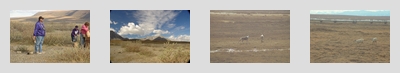
I can’t tell you how flat everything is once we’re out of sight of the buildings in Dead Horse. The farmlands of Ohio are also flat, but there are lines of trees acting as windbreaks spread out among the fields. No trees grow on tunrda: the permafrost is too close to the surface for that. The plain is flat as far as the eye can see, with nothing between the road an the horizon: it’s an ocean of stubby brown grass with snow melt pooling in the fracture lines that lace through the ground, a flat marsh during the summer. On the other side of the road is the shiny steel of the pipeline, looking out of place in this world.
The pipeline isn’t always visible: it’s made to blend into the environment and accomodate the wild life. There are points where the pipeline dips below ground, creating gaps for passing herds of caribou crossing from one side to the other. At other points, the pipeline rises much higher than the typical four or five feet, allowing other animals to go underneath. The metal frames on which the pipeline rests are driven into the permafrost; at many points, those frames have heat sinks attached to them, so as to keep the permafrost cold and frozen. The pipeline itself merely rests on many of those frames, and is allowed to move back and forth on Teflon-coated sliders. The four-foot steel pipe can move like a garden hose, to better accomodate the temperature changes and oil pressure; it’s anchored firmly only at the four-legged frames. And the notion is that, when the oil is done a few decades from now, the pipeline and the road can be taken up, and the tundra returned to its natural condition.
About an hour down the highway, we saw the first instance of height to the east through the fog. This was the edge of plateau or cluster of hills, its slopes rising gently and scenically from the tundra. (I don’t remember what the name of this formation is.) We spent an hour passing it by. The foothills of the Brooks Range slowly became visible on the horizon.
We also saw our first caribou, grazing between the road and the pipeline. The bus stopped for us to get snapshots through the windows. The caribou looked at us curiously and then wandered away through one of the gaps in the pipeline. We would see caribou later (I think they’re the only wildlife we saw on the Dalton Highway besides birds), but this is the closest that we got to them, especially with them standing still for us to take pictures.
(Note that you’re not supposed to stop on the Dalton Highway except for emergencies: it’s a narrow road, and you may get hit by a truck that couldn’t stop fast enough on the gravel. These pauses for the caribou were technically times when the drivers were “doing a safety check”. Later on, coming down from the mountains of the Brooks Range, we actually did make a real emergency stop, as there was acrid smoke pouring out of one of the rear wheel wells. One of the brakes had a valve malfunction, and the brake pad wouldn’t fully disenage. The driver and his trainee went out with a fire extinguisher in case something more important started burning, but didn’t need it. We waited for the brakes to cool, and then they manually released the valve. For the rest of the trip to Fairbanks, they’d stop every once in a while to manually release the valve.)
There were occassionaly rest stops along the way. These rest stops were basically outhouses by the side of the road, composting human waste. (Bring Purell.) Next to these outhouses were bear-proof garbage containers: to open them, you have to pop this latch underneath a cover, and the opening of this cover is too small for a bear’s paw. Around noon, we stopped for a brown bag lunch at one of the larger rest stops in the foothills. There was a tent pitched by campers not to far away: they probably thought they had the whole world to themselves, and then a bus comes by to dump forty tourists on top of them. One of the people on the tour found a dismembered caribou leg not too far from the rest area. He was told to put it back: you’re not supposed to take anything naturally found on the landscape, and you’re not supposed to leave anything that wasn’t there in the first place.
We got into the mountains, but I felt the Brooks Range was more interesting as we approached it than when we climbed it. The road got up to about a mile above sea level, but the vistas weren’t that interesting. Somewhere along the way, we passed a marker indicating the continental divide: water to one side of the sign would drain north, into the tundra and eventually into the Arctic Ocean, and water on the other side would drain south, eventually into the Yukon River and thence into the Bering Sea. We had been driving in the opposite direction from way the water ran in the innumerable streams along the side of the road. Now, we were all going the same way.
I started using the circular polarizer on the wide-angle DX lens and forgot about the vignetting you get with this setup, since the polarizer is a thick filter to start with, and the DX lens is sized to the smaller digital sensor in the camera. Besides that small problem, the polarizer was able to turn the bright sky into a deep blue and take away some of the reflections off the mountains, as it’s supposed to do. Getting the stepdown ring in Anchorage was the right thing to do.
Further down the slope from the Brooks Range, we came across a relatively unique pumping station for the pipeline, one that didn’t have pumps. The pumping stations on the North Slope sent the oil up into the mountains. The first one past these mountains was designed to slow the velocity of the oil as it came down the slope: there was plenty of energy in the flowing oil, so putting more energy into it wasn’t the issue.
There were trees now, short, thin birches. The terrain here is called taiga, Russian for “stick forest”. The trees were as tall as the bus, but not much more so. The trees are almost too thin here to have commercial value, but that’s what slowly grows in this climate.
In this forest, we get to Coldfoot Camp, summer population 30, winter population about 10. There’s a sign there saying that the coldest temperature recorded in North America was in this town. There’s a hotel there, also composed of ATCO housing units (this version one was less comfortable than the one in Dead Horse, actually). Across from the hotel is a gas station and cafe, where we had an all-you-can-eat buffet dinner (the standard practice here, as wait service uses too much labor in this labor-poor region). The food was good, but I thought the Arctic Caribou Inn had better food. There were some flight-seeing tours from here, and one of the couples from our tour went on a rafting trip (which they say was excellent, and that it was a pity no one else went). Besides the Park Service visitors center and the derelict footprint of the old construction camp that was here almost 30 years ago for pipeline construction, that’s all there is to the town. For truckers going north, this is the last service station for the 250 miles to Dead Horse.
The next entry is the Dalton Highway near the Yukon.