Broadway
While half the city has apparently fled the circus around the convention or is joining in the protests, I took a long walk up Broadway in a sort of farewell to this city. Up from the Battery and South Ferry, past Chinatown, past Union Square and Madison Square before the protestors had started to gather, on past Herald Square and Times Square and the looming glass mountain at Columbus Circle, past my home IRT stations at 72nd and 79th. Up through Morningside Heights and Harlem and slowly up Washington Heights and into Inwood, until I saw water again, rushing through the Harlem River Ship Channel separating Manhattan island from Marble Hill and under the Broadway Bridge. All this time, I was taking a picture each block, more or less. I have 254 pictures from just north of South Ferry to the final view of the water in the Ship Channel. Manhattan is around 13.5 miles long, though I’m not sure how long Broadway is in Manhattan. The total time was about seven-and-a-half hours, with time for snacks and lunch at Caffe Swish near Columbia.
(Yes, this is apparently similar to a trip taken by Rosencrans Baldwin last year, but I had a camera, and stuck to Broadway without too many sidetrips, and had a better bathroom break strategy.)
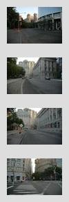
The pictures aren’t particularly exciting: lots of pavements, lots of buildings from uninteresting angles (i.e., just kitty corner across the street). This didn’t turn out to be art photography, and I used the D70 mainly because it had much, much more storage capacity than any other camera I have handy: there will be blown out highlights and murky shadow details that I haven’t fixed in post-processing. Make of them what you will.
I mainly stuck to the eastern side of the street, for sun reasons (better light, and to get out of the sun), deviating a few times to get around the police barricades at the Federal buildings downtown and around construction. Most the shots are pointed up Broadway: I missed a lot of good shots looking down the street, such as the Flatiron and Woolworth Buildings, which was a pity. Maybe a decade from now, I’ll do a walking-down-Broadway photo tour. The great mistake, though, was not taking a picture of the waters of New York Harbor lapping against the rocks of the Battery Park shoreline. This series could then have been bookended by water.
I started at around 7:20 when I got off the IRT at South Ferry and walked up State Street, bordering Battery Park, to get to the foot of Broadway, and then continued up from there (pic #1). I hit Canal Street at 7:50 (pic #29) and north Union Square (pic #53) by 8:20. My schedule was to get past the protest zone before stuff started, though I did see the news people setting up their crane for the overhead shot of any crowd that comes marching down Broadway, and there was a group of protestors carrying red flags that stopped in the nearby Starbuck’s for a latte. I followed them in for a snack and restroom break.
Resuming about half an hour later, I got to Times Square (pic #83) by 9:20 and Columbus Circle (#96) by 9:45, where I stopped at the Whole Foods Jamba Juice for another drink — it was going to be a hot day. I got to 77th Street (#116) at around 10:30 and stopped at home to check email. 96th Street (#135) , a bit past the half way mark, was at 11:10, and Columbia (#155) was around 11:30, where I stopped for lunch. There are a lot more restaurants and coffee places at the main campus: in the early 1990s, the only place to get coffee and sit was the Hungarian Pastry Shop. No more.
Harlem and Washington Heights in the early afternoon were lively with street life. There were a lot of street vendors hawking all sorts of goods, and a lot of fruit stands with cleverly sliced up mangos and pineapples on skewers for snacking. Interestingly, at 144th Street (#181, around 12:45), a trio of Chinooks flew past, going north along the Hudson. They make a different sound from the smaller police helicopters that hover over the city. Presumably, these Convention-related flights. Cheney just arrived at this time? Interestingly, while Manhattan south of, say, Columbia’s main campus was rife with little anti-Bush stickers and signs and protestors going to the neighborhood subway station to go downtown, I didn’t see many (any?) north of 125th Street. Up around 176th Street (#212), there was in fact a large pro-Bush banner.
I got up to Columbia Presbyterian (#201) at around 1:15 and stopped at Carrot Top for some ice coffee and a yummy muffin. I got to 181st (#217) at 2PM, and realized I’m more familiar with Ft. Washington than Broadway at that street, that Ft. Washington was over a bit to my left. Around here, Broadway curves so that the afternoon sun is on my back, and there’s no shade on the east side of the street. I’m tempted to cross to the west side and take pictures from there, but decide to tough it out.
Somewhere around 190th Street (#225), the numbered grid disappears and I went up Broadway crossing named streets, wondering how much further I had to go. They reappeared after some ten or fifteen blocks. I popped into the 207th Street IND station (#241) to take a look at the detailed MTA neighborhood map to see that it wasn’t far now. The 207th Street station has amusing mosaic work: “At Last… The End.” I believe the A line, which terminates there, has the longest run of all the subway lines, finishing in far-off Far Rockaway. The mosaic’s message and encouragement was appropriate for my little trip, too: I was almost at the tip of the island.
I passed 215th Street (#247), where the IRT is once again an el, and which would be last stop for the 1 on Manhattan Island. A few blocks up from there is Baker Field (#249), which I never visited while I was at Columbia and was now seeing for the first time. A few blocks past the stadium, underneath the el tracks, Broadway and 9th Avenue cross each other again. 9th Avenue (#252) is the last street before the Broadway Bridge and the waters of the Channel. It was about 2:50PM now. After admiring the swirling waters a bit, I made my way back to the 215th Street station to take the train home (what I should have done is go to the Marble Hill Station, which was closer, and technically still a part of Manhattan county, which would have been a more complete final waypoint; Marble Hill Station was visible just past the bridge, and I foolishly turned south instead of north).
That’s basically it. I wish the pictures were better. But, still, it’s a set of photos that stretch from the temples of finance to the seedier parts of town, with bright, colorful, chaotic city life along the way.